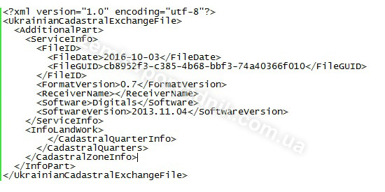
XML exchange file of a land plot in Ukraine
Information about a land plot is entered into the State Land Cadastre (SLC), in particular, by submitting an exchange file (electronic document) in XML format to the cadastral registrar. The exchange file is created by a certified land surveyor and must be certified by the latter's electronic digital signature.

The content, structure and technical characteristics of the exchange file must comply with the requirements of the Procedure for Maintaining the State Land Cadastre, approved by Resolution No. 1051 of 17.10.2012. of the Cabinet of Ministers of Ukraine.
Some cases in which the development of an XML exchange file is required:
- primary registration of a land plot in the SLC (primary allotment, division, merger, assignment of a cadastral number to a land plot);
- entering data on a land plot that has previously been assigned a cadastral number but is not in the cadastre;
- correction of errors in the data on the land plot (area, designated purpose, data on the owner/user, location/address of the land plot);
- in some cases, elimination of overlap with other land plots, change of configuration and/or actual location of the land plot on the ground.
Starting from 2022, the application, together with an electronic document (exchange file), shall be submitted to the state cadastral registrar only in electronic form by a certified land surveyor. The said procedure is regulated, in particular, by clauses 110, 110-1, 110-2 of the Procedure for Maintaining the State Land Cadastre.
It should be noted that errors in data or overlaps of land plots may not always be eliminated through an XML exchange file (electronic document). In complicated cases (e.g., displacement of the plot), it will be necessary to order the development of technical documentation for establishing the boundaries of the land plot in kind (on the ground). Such technical documentation will already contain an exchange file.
You can learn more about this in our article Technical documentation for establishing the boundaries of a land plot in kind (on the ground).
Also, don't forget to like our beautiful Facebook and Instagram pages;)
See also: rights registration to a land plot in Ukraine, changing the purpose of a land plot, legalizing unauthorized construction in Ukraine


