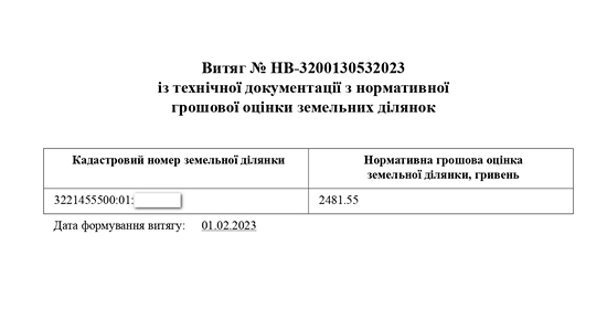
Normative monetary valuation of a land plot in Ukraine
Normative monetary valuation is one of several types of valuations provided for by the Law of Ukraine "On Land Valuation", the basis of which is the rental income from the use of a land plot over a certain period of time. The concept of normative monetary valuation is also defined in Article 1 of the Law of Ukraine "On Land Valuation".

The normative monetary valuation of a land plot is based on rental income. For a simplified understanding, rental income is essentially the money that can be earned from the most efficient use of a land plot for its intended purpose.
For an agricultural land plot outside of a settlement, this income will be determined as a result of the sale of grain grown on the land plot over a certain period of time. In this case, if the land plot belongs to a private person, the quality of the soil covering such land plot is also taken into account.
Within a settlement, the normative monetary value of a land plot is calculated per 1 square meter. The calculation depends on many factors, including:
- functional use of the land plot;
- location of the land plot;
- soil quality;
- environmental situation;
- other factors.
Each year, the normative monetary value is subject to mandatory indexation taking into account the inflation rate of the previous year. The StateGeoCadastre of Ukraine and its local units are responsible for indexing the normative monetary value, and they must index the normative monetary value for submission to the interested parties (tax authorities, citizens, organizations) by January 15 of each year.
Why is normative monetary valuation necessary?
Normative monetary valuation is usually required in the following cases:
- during the sale of agricultural land;
- to calculate the land payment;
- to calculate the amount of rent when leasing a land plot;
- to calculate losses in forestry and agricultural production;
- to calculate the payment of taxes when executing contracts of sale, exchange, and donation of land;
- in case of inheritance of a land plot.
In the above cases, it is necessary to obtain an extract from the normative monetary valuation of the land plot. In addition to the extract from the technical documentation on the normative monetary value, the notary may also require an extract from the cadastre (SLC) when notarizing the agreement.
It is important to note that if the cadastre does not contain information on the current land use code, it is impossible to obtain an extract on the normative monetary value of the land. The system automatically calculates the normative monetary value based on the land plot's designated purpose code, which in turn determines the coefficient included in the formula for calculating the NMV.
For more details, please read our article on the procedure for assigning a land plot designation code.
The procedure for obtaining an extract on the normative monetary value of a land plot
A while ago, the possibility of ordering an extract of normative monetary valuation online was introduced. To order an extract on NMV online, go to the electronic cabinet of the StateGeoCadastre, select "Information of the State Land Cadastre", log in, fill out the electronic form and receive the relevant extract.
If, for some reason, you are unable to order an extract from the NPO online, the procedure for obtaining an extract in the traditional way by submitting an application to the administrative service center in your district is described below.
To obtain a certificate (extract) of the normative monetary value, you must contact your local administrative service center. If there is no such center in your area, you should contact the local department of the StateGeoCadastre directly and provide the following list of documents:
- application for issuance of a certificate (extract) of normative monetary valuation for an individual;
- a power of attorney for a representative if the documents are not submitted personally by the owner (user) of the land plot.
An extract on an NPO may be refused if:
- technical documentation on the normative monetary valuation of the land plot has not been developed;
- the cadastre does not contain a code for the purpose of the land plot;
- the land plot has not been formed, in particular, it does not have a cadastral number.
Normative monetary valuation of agricultural land and land in settlements
Below, we provide for reference the normative monetary valuation of agricultural land for 2023, as well as residential land as of 2022.
Download Normative monetary valuation of agricultural land for 2023 in .xls format (26 Kb)
Download Normative monetary valuation of land in settlements as of January 01, 2022 in .xlsx format (4 Mb)
Please note that in the table of normative monetary valuation of land in settlements, the column with the average value of one square meter of land is highlighted in yellow for convenience.
To get an accurate and official figure of the normative monetary value of your land plot, you need to order an extract from the technical documentation on the normative monetary value of the land plot.
Regulatory and legal acts
- The Law of Ukraine "On Land Valuation";
- Resolution of the Cabinet of Ministers of Ukraine No. 1147 dated 03.11.2021 "On Approval of the Methodology for Normative Monetary Valuation of Land Plots".
Also, don't forget to like our beautiful Facebook and Instagram pages;)
See also: division of a land plot in Ukraine, assigning a cadastral number, state act on a land plot


